Social Icons

Pages

Featured Posts

Wednesday, May 20, 2015

Taprom Temple

Taprom Temple

History[edit]

Foundation and expansion[edit]

In 1186 A.D., Jayavarman VII embarked on a massive program of construction and public works. Rajavihara ("monastery of the king"), today known as Ta Prohm ("ancestor Brahma"), was one of the first temples founded pursuant to that program. The stelecommemorating the foundation gives a date of 1186 A.D.[3]
Jayavarman VII constructed Rajavihara in honor of his family. The temple's main image, representing Prajnaparamita, the personification of wisdom, was modelled on the king's mother. The northern and southern satellite temples in the third enclosure were dedicated to the king's guru and his elder brother respectively. As such, Ta Prohm formed a complementary pair with the temple monastery of Preah Khan, dedicated in 1191 A.D., the main image of which represented the Bodhisattva of compassionLokesvara and was modelled on the king's father.[4]
The temple's stele records that the site was home to more than 12,500 people (including 18 high priests and 615 dancers), with an additional 800,000 souls in the surrounding villages working to provide services and supplies. The stele also notes that the temple amassed considerable riches, including gold, pearls and silks.[5] Expansions and additions to Ta Prohm continued as late as the rule of Srindravarman at the end of the 15th century.

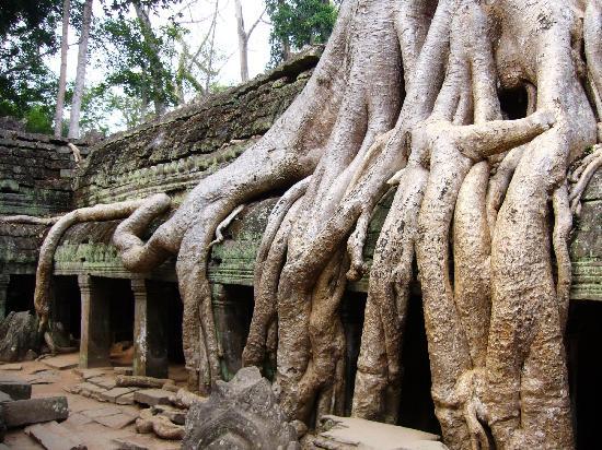
Abandonment and Restoration[edit]


Tree at Ta Prohm
After the fall of the Khmer Empire in the 17th century, the temple of Ta Prohm was abandoned and neglected for centuries. When the effort to conserve and restore the temples of Angkor began in the early 21st century, the École française d'Extrême-Orientdecided that Ta Prohm would be left largely as it had been found, as a "concession to the general taste for the picturesque." According to pioneering Angkor scholar Maurice Glaize, Ta Prohm was singled out because it was "one of the most imposing [temples] and the one which had best merged with the jungle, but not yet to the point of becoming a part of it".[6] Nevertheless, much work has been done to stabilize the ruins, to permit access, and to maintain "this condition of apparent neglect."[4]
As of 2013, Archaeological Survey of India has restored most parts of the temple complex some of which have been constructed from scratch.[2] Wooden walkways, platforms and roped railings have been put in place around the site to protect the monument from further damages due to the large tourist inflow.

The Site[edit]


Roots of a spung running along the gallery of the second enclosure.

Layout[edit]

The design of Ta Prohm is that of a typical "flat" Khmer temple (as opposed to a temple-pyramid or temple-mountain, the inner levels of which are higher than the outer). Five rectangular enclosing walls surround a central sanctuary. Like most Khmer temples, Ta Prohm is oriented to the east, so the temple proper is set back to the west along an elongated east-west axis. The outer wall of 1000 by 650 metres encloses an area of 650,000 square metres that at one time would have been the site of a substantial town, but that is now largely forested. There are entrance gopuras at each of the cardinal points, although access today is now only possible from the east and west. In the 13th century, face towers similar to those found at the Bayon were added to the gopuras. Some of the face towers have collapsed. At one time, moats could be found inside and outside the fourth enclosure.
The three inner enclosures of the temple proper are galleried, while the corner towers of the first enclosure form a quincunx with the tower of the central sanctuary. This basic plan is complicated for the visitor by the circuitous access necessitated by the temple's partially collapsed state, as well as by the large number of other buildings dotting the site, some of which represent later additions. The most substantial of these other buildings are the libraries in the southeast corners of the first and third enclosures; the satellite temples on the north and south sides of the third enclosure; the Hall of Dancers between the third and fourth eastern gopuras; and a House of Fire east of the fourth eastern gopura.

Tuesday, May 19, 2015

Angkor Thom

Angkor Thom


The site


The city lies on the west bank of the Siem Reap River, a tributary of Tonle Sap, about a quarter of a mile from the river. The south gate of Angkor Thom is 7.2 km north of Siem Reap, and 1.7 km north of the entrance to Angkor Wat. The walls, 8 m high and flanked by a moat, are each 3 km long, enclosing an area of 9 km². The walls are of laterite buttressed by earth, with a parapet on the top. There are gates at each of the cardinal points, from which roads lead to the Bayon at the centre of the city. As the Bayon itself has no wall or moat of its own, those of the city are interpreted by archaeologists as representing the mountains and oceans surrounding the Bayon's Mount Meru.[3]:81 Another gate—the Victory Gate—is 500 m north of the east gate; the Victory Way runs parallel to the east road to the Victory Square and the Royal Palace north of the Bayon.

The faces on the 23 m towers at the city gates, which are later additions to the main structure, take after those of the Bayon and pose the same problems of interpretation. They may represent the king himself, the bodhisattva Avalokiteshvara, guardians of the empire's cardinal points, or some combination of these. A causeway spans the moat in front of each tower: these have a row of devas on the left and asuras on the right, each row holding a naga in the attitude of a tug-of-war. This appears to be a reference to the myth, popular in Angkor, of the Churning of the Sea of Milk. The temple-mountain of the Bayon, or perhaps the gate itself,[3]:82 would then be the pivot around which the churning takes place. The nagas may also represent the transition from the world of men to the world of the gods (the Bayon), or be guardian figures.[4] The gateways themselves are 3.5 by 7 m, and would originally have been closed with wooden doors.[3]:82 The south gate is now by far the most often visited, as it is the main entrance to the city for tourists.

At each corner of the city is a Prasat Chrung—corner shrine—built of sandstone and dedicated to Avalokiteshvara. These are cruciform with a central tower, and orientated towards the east.
Within the city was a system of canals, through which water flowed from the northeast to the southwest. The bulk of the land enclosed by the walls would have been occupied by the secular buildings of the city, of which nothing remains. This area is now covered by forest.
Most of the great Angkor ruins have vast displays of bas-relief depicting the various gods, goddesses, and other-worldly beings from the mythological stories and epic poems of ancient Hinduism (modified by centuries of Buddhism). Mingled with these images are actual known animals, like elephants, snakes, fish, and monkeys, in addition to dragon-like creatures that look like the stylized, elongated serpents (with feet and claws) found in Chinese art.
But among the ruins of Ta Prohm, near a huge stone entrance, one can see that the “roundels on pilasters on the south side of the west entrance are unusual in design.”
What one sees are roundels depicting various common animals—pigs, monkeys, water buffaloes, roosters and snakes. There are no mythological figures among the roundels, so one can reasonably conclude that these figures depict the animals that were commonly seen by the ancient Khmer people in the twelfth century.[4]

Angkor Wat History

History


Angkor Wat lies 5.5 kilometres (3.4 mi) north of the modern town of Siem Reap, and a short distance south and slightly east of the previous capital, which was centred at Baphuon. It is in an area of Cambodia where there is an important group of ancient structures. It is the southernmost of Angkor's main sites.

According to one legend, the construction of Angkor Wat was ordered by Indra to act as a palace for his son Precha Ket Mealea.[4] According to the 13th century Chinese travelerDaguan Zhou, it was believed by some that the temple was constructed in a single night by a divine architect.[5]
The initial design and construction of the temple took place in the first half of the 12th century, during the reign of Suryavarman II (ruled 1113 – c. 1150). Dedicated to Vishnu, it was built as the king's state temple and capital city. As neither the foundation stela nor any contemporary inscriptions referring to the temple have been found, its original name is unknown, but it may have been known as "Varah Vishnu-lok" after the presiding deity. Work seems to have ended shortly after the king's death, leaving some of the bas-relief decoration unfinished.[6] In 1177, approximately 27 years after the death of Suryavarman II, Angkor was sacked by the Chams, the traditional enemies of the Khmer. Thereafter the empire was restored by a new king, Jayavarman VII, who established a new capital and state temple (Angkor Thom and the Bayon respectively) a few kilometers to the north.
In the late 13th century, Angkor Wat gradually moved from Hindu to Theravada Buddhist use, which continues to the present day. Angkor Wat is unusual among the Angkor temples in that although it was somewhat neglected after the 16th century it was never completely abandoned, its preservation being due in part to the fact that its moat also provided some protection from encroachment by the jungle.[7]
One of the first Western visitors to the temple was António da Madalena, a Portuguese monk who visited in 1586 and said that it "is of such extraordinary construction that it is not possible to describe it with a pen, particularly since it is like no other building in the world. It has towers and decoration and all the refinements which the human genius can conceive of."[8] In the mid-19th century, the temple was visited by the French naturalist and explorer, Henri Mouhot, who popularised the site in the West through the publication of travel notes, in which he wrote:
"One of these temples—a rival to that of Solomon, and erected by some ancient Michelangelo—might take an honorable place beside our most beautiful buildings. It is grander than anything left to us by Greece or Rome, and presents a sad contrast to the state of barbarism in which the nation is now plunged."[9]
Mouhot, like other early Western visitors, found it difficult to believe that the Khmers could have built the temple, and mistakenly dated it to around the same era as Rome. The true history of Angkor Wat was pieced together only from stylistic and epigraphic evidence accumulated during the subsequent clearing and restoration work carried out across the whole Angkor site. There were no ordinary dwellings or houses or other signs of settlement including cooking utensils, weapons, or items of clothing usually found at ancient sites. Instead there is the evidence of the monuments themselves.[1


Blogger Templates